6.0 Magnitude Earthquake in Afghanistan Killed More Than 800 Dead and Left 2,800 Injured
-
Web Desk
-
- Published September 1, 2025
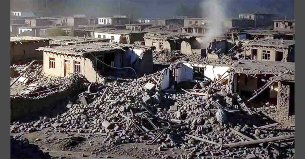
On August 31, late in the day, a 6.0 earthquake in Afghanistan was recorded, near the provinces of Nangarhar and Kunar which borders Pakistan. According to the official reports, at least 812 have been killed and far more than 2,800 injured. Rescuers are attempting to locate survivors as death toll rising.
Earthquake in Afghanistan: Magnitude and Location
The depth of the Afghanistan earthquake today was approximately 10km and the damage was more on the surface. The shocks were felt all around Jalalabad and the other districts, but much weaker shocks were experienced in Kabul and in Peshawar. The US Geological Survey estimated the magnitude of the earthquake as strong to severe in the area of the epicentral.
In Afghanistan, over 800 deaths and approximately 2,800 injuries due to the earthquake have been confirmed by the authorities. Hardest-afflicted regions were Kunar and Nangarhar, with extensive destruction of mud-brick buildings, blocked roads and fallen infrastructure. Villages close to the epicenter have been worst hit and survivors are being moved to hospitals in Jalalabad and Kabul.
Helicopter-supported emergency teams have been rescuing the injured in remote locations. More than 40 helicopter have already delivered wounded and dead to major hospitals. Landslides and damaged roads in mountainous areas are slowing down relief work.
The Afghanistan earthquake continues to affect thousands of people and law enforcement agencies are fearing that the number of victims may continue to increase as the rescuers access more distant villages. The international organizations are monitoring the situation and are preparing to provide humanitarian assistance.
Web Desk
Hamariweb.com Webdesk is where to get the latest news feeds on current affairs, cultural activities, and current news in Pakistan and other parts of the world. Our team is led by a sharp editorial mind and accuracy and works to make the reader feel updated and motivated with journalistic accuracy and the power of the story. Everyday news, headline news, news stories, breaking news, major news, minor news, we have the heartbeat of the nation on your screen--always relevant and with links.


Leave a Reply